Bowen Island is a small,well, Island near Vancouver. A sort of a weekend retreat for the people of Vancouver, it has a number of options to either relax or do some hiking and kayaking. Or if you want to do nothing you can just go and relax there.
Keeping in mind my systematic increase of intensity of the hikes I was doing while in Canada, I decided to do the Mt Gardner Trail on Bowen Island. It was a step up from the previous hikes of Quarry Rock and Lighthouse Park. In fact they were more of a stroll than a hike. The Mt Gardner trail,on the other hand, has an elevation gain of around 650 Mtrs which is a decent climb for a day hike.
My friend from University, Douglas who is from Guatemala, was joining me. He had done some awesome hikes before, including climbing some volcanoes in addition to doing endurance races. One couldn't ask for a better hike buddy.

On the day of the hike we started quite early in the morning and reached Horseshoe Bay from where we were to catch a ferry to reach the island. Now, I like ferries, so I was equally excited about this part of our trip as well. Operated by BC Ferries, this journey offered excellent views of the surrounding mountains. The weather was excellent with the sun shining warmly above. Not too hot and not too cold. Just the perfect weather for a hike. The ferry itself was sparsely occupied.There were not many people around. We both stood in front of the windows like two officers on deck. This ferry called 'Queen of Capilano' is, as a google search told me, a 2500 Tonne vessel with a top speed of 12 knots. It can carry around 100 cars and around 400 people. After a quick 20 mins journey we reached Bowen Island. As the ferry slowly glided towards the the unloading area of the Island it reminded me of the movie Jurassic Park with its tall gate. We made our way out of the ferry and following the crowd, headed to the town.
Here we were a bit confused about which road to take to reach the starting point of the Mr Gardner Trail. Douglas suggested we better ask someone instead of just following the map we had. So we entered a Bar and asked the guy there. He turned out to be very helpful, showing us the directions patiently. We thanked him profusely and left for the trail.
Following his directions we walked for quite a bit before we reached the starting point of the trail. but before we did we came across a beautiful lake. From afar we could see the trees stacked against the shimmering white of the water. As we approached nearer we could see the huge lake beyond the trees. There was some picnic tables at the edge of the water. It was a beautiful place. I remarked to Douglas that one can spend the whole day just chilling here. We roamed around the edge of the lake for a while and continued on towards the trail.
Soon we reached the base of the Mt Gardner trail. It was around 1130 am now. The elevation at this point was 66 MSL. The sun was still shining warmly above and off we started on our hike. It starts off a wide dirt road but soon narrows down to a trail. We trundled on for a while. Initially there is not much on offer just the tall trees and the quietness of the place. Perfect for some nice conversation. Specially when you have interesting people around. Douglas regaled me with his experiences from back home.

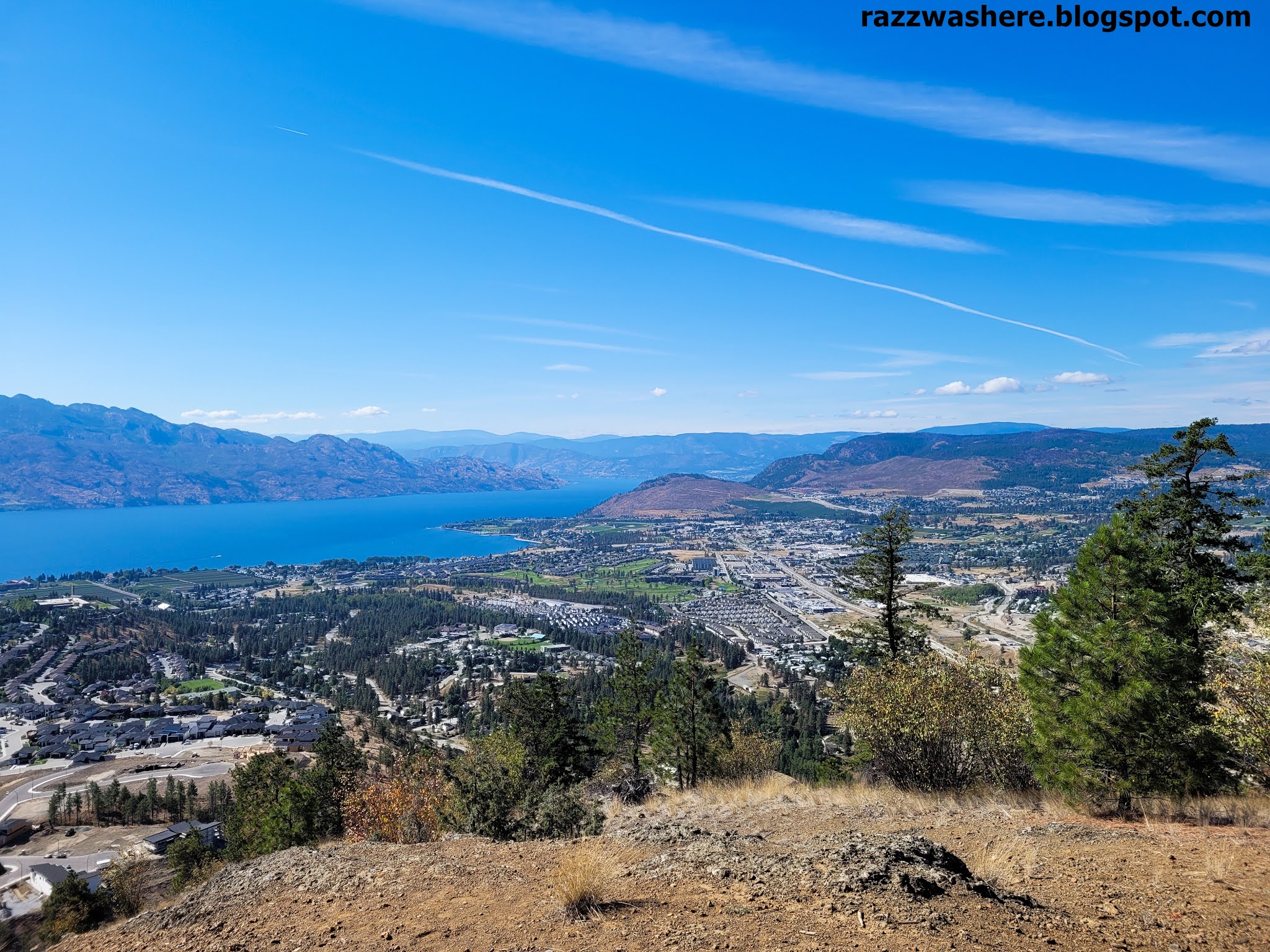
Soon we reached a point with a clearing at the edge of the hill. This point offered spectacular views of the surroundings. We were delighted looking at the view. Douglas remarked aloud what I had in mind. This was better than what we had expected. So we took a short break here. There were a number of smooth rocks offering a nice place to just sit down for a while and unwind which is exactly what we did. And there weren't many people on the trail and the solitude was wonderful. We met just 4 people the whole time. The sun was still shining warmly above and as we sat there, the blue of the seas in front of us offered a pleasing sight. Directly on the opposite side was the blue sea and beyond it, land. Far away, the snow covered mountains were visible. Now and then a gentle breeze was blowing. The whole scene was pretty relaxing.
It was 1310 now and the elevation at this point was 560 MSL.
Soon, we left this point and continued our way further up. Somewhere around this point we lost our way. We didn't realize it immediately but later found out when the trail disappeared. Some little bit of wandering here and there got us back to the right path.
Now we reached a point where the climb got quite steep. It was 1332 Hrs now and the elevation at this point was 660 MSL. We started climbing this steep section. There were a couple of ropes hanging down from the top. Someone had tied these ropes to the trees at the top. Though we could climb without using the ropes it proved very helpful later during the descent.

After this steep section, a brief walk finally led us to the top. The view that greeted us at the top was spectacular. To our right, emerging out from the tops of the trees lining the edge was the view of the surrounding seas and the mountains beyond. At the edge was a platform to sit and enjoy the views. To our front was a tower and a small house. To our left was again views of the sea but it was not visible from where we were right now. We first headed to the wooden platform I mentioned before. Here we sat down facing the sea and enjoyed the atmosphere. First we had something to eat. And then took a short nap. The feeling was amazing. I lied down on the warm wooden platform stretching my legs to my fullest. I covered my eyes with one hand to shield them from the sun's rays. There was no sound anywhere except the sound of the wind ruffling the leaves of the trees now and then. With the sun above giving off its warmth, I slowly drifted off into a sleep that can only come in such places and situations. The last time when I fell into such slumber was many years ago back in India, when I fell asleep near a river bank, on the warm sand. I don't know for how much time I slept but when I got up and looked around Douglas was strolling around exploring the place. I called him over and we took some pics before heading to the other side of the top. This place offered some awesome views too. The most interesting thing for us was that we could spot our University from here. There was another viewing platform here and again we sat down and spent some time here. The elevation at this top most point was 724 MSL. We started our descent at around 1500 Hrs.

At around 1600 Hrs we reached the bottom and we made our way back to the Ferry terminal.
Looking up the schedule we found out that the next ferry was still some 40 mins away so we strolled around the area a bit before finally our ferry arrived. .
In a couple of hours we were back in our homes. It was a wonderful hike and much better than the previous hikes I did in Canada
In Brief
- Mt Gardner Trail - 650 Metres elevation gain.
- Takes about 2 hours to climb and 1 hour to descend.
- Highest Point - 724 MSL